
March 7, 2025
A rendering included in the Morrissey Commission "draft" report posted on March 6, 2025. MassDOT image
A state-led commission focused on the re-construction of the Morrissey Boulevard corridor from South Boston to Neponset has issued its “draft” final report for public review. The 181-page document was posted on a state-run website last night.
A public meeting to discuss the report— and next steps— will be held on Thurs., March 20, from 6 to 8 p.m. at the Hilton Inn Express Boston hotel next to South Bay Mall, according to a statement from MassDOT, the state agency that has led the commission’s work since Nov. 2023.
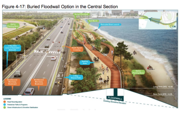
The draft offers new images and details about key elements of potential improvements, including proposed flood mitigation efforts between UMass Boston and Freeport Street. It seems to take heed of negative community feedback against the addition of a sea wall— 12 feet high in some places—that would have run along the roadway along Savin Hill and Malibu beaches.
Instead, the report includes a raised berm with a pathway running on top of it, which would serve a dual purpose as flood protection and an amenity for pedestrians and cyclists.
This hybrid suggestion looks to connect the Neponset Greenway to a series of paths on top of the buried flood wall, a suggestion put forward by Councillor John FitzGerald last November.
While leaving the matter open for further discussion, another option put forward is a buried “structural floodwall topped with a nature walk including a multi-use greenway and a bicycle and pedestrian facility on the west side.”
Offered as a way to enhance neighborhood access to the new waterfront would be a signalized crosswalk on Morrissey, with one alternative a pedestrian bridge over the Boulevard. That would be bolstered by a tide gate that is opened less frequently, a new living shoreline and dune placement extending into the harbor, and a built-up beach area on the bayside.
“With community involvement and the anticipated future severity of climate change flooding, it is crucial that decision makers coordinate with the community to make decisions on flood mitigation measures (on this section of Morrissey),” the report notes.
“Such measures may need to balance the potential severe flooding, environmental assets, and placemaking opportunities, which include the potential for expanding recreation and transportation assets and enhancing existing ones.”
On Friday, FitzGerald said he was still carefully reviewing the report, but was encouraged that MassDOT planners had used the suggestion of making the wall more of an amenity for walking and biking. His only pause was that the roadway had been pared down to two lanes in each direction with bike paths alongside them. He suggested that maybe the bike paths should connect to the new Neponset Greenway atop the new buried flood wall.
“I still question the need for installing bike lanes on Morrissey if we have a beautiful path to connect to on the multi-modal resilience piece,” he said. “Let’s put them on the resilience piece and see how that goes. If need be, we can add them back. Adding is always easier than removing, and more cost-effective.”
The report also suggested the flooding solution could be a boon for ecology along the waterfront using “nature-based solutions” to curb flooding and lead to a healthier coastal ecosystem.
That said, much of the commission’s work focused on engineering fixes to key intersections along the corridor to promote better driving conditions, but also to create more east-west connections for Savin Hill – with the draft identifying plan alternatives that they believe will best serve the corridor into the years 2050 to 2070.
Though the preferred alternatives for the five key intersections had been hinted at in previous meetings, the report made it clear which option the state preferred after weighing multiple computer-tested models, on-site observations, and community input.
The preferred designs were as follows:
• Neponset Circle - Modified DCR Design
• Freeport Street - Modified DCR Design
• Bianculli Boulevard - DCR Design
• First Street - Signalized Control
• Preble Street - Signalized Control
Some interesting things noted in the report include:
• State leaders left several things open for further study between the end of the Commission and actual construction. One of those was the issue of what neighbors have called “comprehensive planning” that went beyond roadways and delved into utilities and infrastructure.
“Multiple themes pertinent to future potential project development arose during this study,” read the report. “These included evaluating the changes that could be necessary to existing utility systems on and adjacent to Morrissey Boulevard, such as electrical lines and drainage systems, potential additional wayfinding signage to navigate key corridor connections, and planting treatments (increased tree cover and planting native species).”
•The U-turn at Pope’s Hill near the Dunkin Donuts is proposed to be eliminated, and future study is called for in to look into making Conley Street a fully signalized intersection to improve access to Port Norfolk.
•Many have long assumed the Morrissey corridor served those commuting from the South Shore, but analysis done within the report revealed that most of those using the corridor are Boston residents from adjacent neighborhoods looking to get downtown while avoiding the interstate.
Data showed that 48 percent of vehicles in the morning peak originated in Boston neighborhoods south of the study area. Those from Quincy accounted for 16 percent and Braintree came in at 4 percent. Some 73 percent were destined for downtown or the Back Bay.
After the March 20 meeting, MassDOT will release a final report, schedule another public meeting within the mandated 60-day comment period, and eventually turn the study over to the Legislature.
The initial reaction to the report from some in the community was confusion because they thought the report would be issued after the March 20 meeting.
“It’s disappointing that they are looking for reaction to the report rather than to craft it with the community,” said Bill Walczak, the president of the Columbia-Savin Hill Civic Association, which logged a vote of “no confidence” in the state’s effort last October.
“The way to get around disappointment is not to foist a plan on us and try to get us to react to it,” he added. “It’s just not a good way to talk to a community.”
Last year, the commission extended its own deadline to offer a report to the Legislature by Dec. 31, 2024, and later moved that date into 2025.
“The work of the Morrissey Boulevard Commission and the Morrissey Boulevard Corridor Study represents key foundational steps for future potential improvements to the Morrisey Boulevard corridor,” read the report. “With continued interagency coordination and community collaboration, changes to the corridor could be advanced to improve current and future transportation conditions, mitigate flooding, address environmental challenges, and enhance quality of life for Boston residents.”
Officials have previously projected that a full modernization of the state road system along Morrissey could cost between $273 million to $352 million over a five-year period, but the draft report identified lower cost estimates that are now between $235 million and $304 million.
That cost range does not include repairs or replacements of the Beades drawbridge or the Kosciuszko Circle (K-Circle) rotary. Actual construction would not likely begin until five years from now, in 2029 or 2030, and there are a variety of funding sources identified in the draft report.
Most prominent was the traditional federal Transportation Improvement Program (TIP) administered by the regional Metropolitan Planning Organization (MPO). However, other ideas were floated as well, including a District Improvement Financing (DIF), which is a way of planning for an area and designating future tax revenues from private investment projects to pay for public infrastructure programs.
“While this report outlines potential improvements for the entirety of the corridor, the alternatives could be advanced in stages,” read the report. “Phased construction stages could also allow for funding to be secured as applicable to respective corridor sections, as well as designating sections that could have additional permitting challenges. Corridor improvements that could align with mitigation for future development projects could also be identified by project proponents.”
Villages:
Topics:

