August 25, 2010
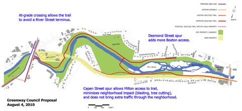
 Greenway Council proposal: A proposal by the Neponset Greenway Council would include trail extensions on both sides on the river.
A multi-use path along the Neponset River will not go through Milton’s Capen Street neighborhood under an agreement a state senator says he has reached with the state’s Department of Conservation and Recreation. The agency is weighing several ways to connect Pope John Paul II Park to the Hyde Park neighborhood, and Milton’s Central Ave. to Mattapan Square, since the trail currently runs 2.5 miles from Pope John Paul II Park to Central Ave.
Some residents of the Capen Street neighborhood objected to proposals that included the path going through their street, arguing that the plans call for blasting of rock near their homes and the destruction of trees.
“It was not just a case of ‘Not in My Backyard’; it was a case of this path would essentially take away people’s yards,” said state Sen. Brian A. Joyce, who represents Milton. “It would by necessity destroy mature plantings and trees and also likely require some significant blasting to really destroy the peaceful use and enjoyment of homes.”
Joyce told the Reporter that no final decision on the path’s route has been made. He has met with Department of Conservation and Recreation Commissioner Rick Sullivan, who told him Capen Street would not be included in the proposal.
“I appreciate that the commissioner was sensitive to neighborhood concerns and that the process will move forward, and I think it will have a happy ending,” Joyce said. “We all want the path to go forward.”
The news about Capen Street was first reported by the Patriot Ledger.
Sullivan told the Reporter this week that no final decision about the route has been made. While Sullivan did not contradict Joyce’s account of his meeting, he said that the public comment period— which officially ended on Aug. 14— was still ongoing. Last week, Sullivan’s office received a detailed proposal from the the Neponset Greenway Council, a volunteer group that has advocated for riverside improvements for the last 16 years. The Council’s proposed option— which includes trails on both side of the Neponset river— would also feature a “spur” close to the Capen Street neighborhood.
Sullivan said that the Greenway Council had a “phenomenal” track record of advocacy along the Neponset.
Five options originally presented by consultants hired by the DCR include:
“Option A,” which would run exclusively along the Milton side of the Neponset River, largely following the high-speed trolley line and separated from homes by the railway.
“Option B,” which would start out on the south side and then cross over to the north side through a bridge and exit through the Mattapan MBTA station and busway onto narrow River Street.
“Option C,” which would stay on the northern side of the river and would be separated from housing through River Street.
Option D,” which would run on the south side of the river but include a connection to the north side in its middle.
“Option E,” which would start out on the south side of the river, cross over to the north side, and then cross back over to the south side, following the trolley line.
The route would go through Capen Street in Options “A,” “D,” and “E.”
The project is expected to cost between $3 million and $5 million.
Valerie Burns, the president of the Boston Natural Areas Network, submitted the Greenway Council’s proposal on behalf of her membership. She said this week that she was concerned that some options were being taken off the table “prematurely.”
The option submitted by the Greenway Council attempts to keep the trail close to the river, having it cross over into the eastern end of Ryan Playground and then include a crossing at Mattapan Station. The Council plan includes two “spurs” that would allow additional paths on both sides of the river, including one that would branch into the Capen Street neighborhood.
“The idea would be to really capture the park and its facilities for people who are walking or riding in this section, and continue the trail down the Mattapan side of the river until you get into Mattapan Station,” Burns said.
A former Milton town official, John Cronin, is offering another alternate proposed route. Cronin’s route is based largely on “Option C,” with the path running on the Boston side for about 15,000 feet, and it would avoid unduly burdening any area homes, Joyce said.
State Rep. Linda Dorcena Forry, who represents parts of Milton and Mattapan, said she understands if Capen Street residents do not want the trail to connect to their street. Forry, who is married to Reporter managing editor Bill Forry, said she wants both Boston and Milton communities to be included in the options. “If it’s not Capen St., we have to look at other options,” she said.
Tags:


