June 28, 2018

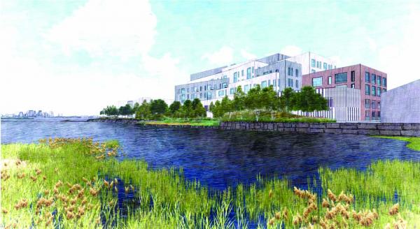
A rendering from across Pine Neck Creek, near Tenean Beach, of the proposed Neponset Wharf project. City Point Capital image
For residents of the small Port Norfolk peninsula, a chief concern with the proposed Neponset Wharf project is the integrity of the shoreline and construction impacts on marine life. While those issues took center stage at a public meeting on Monday, a fundamental unease with the project itself continues to underlie all discussions among neighbors and members of the Impact Advisory Group.
In City Point Capital’s proposal, the existing marina area would be rehabilitated and dredged. Boat storage and service facilities would be renovated. On the non-waterfront-use side, the 240,800-square foot development is looking at 96 condominiums, 170 parking spaces, and space for a small neighborhood market and deli.
On Monday, Seth Latrell, an environmental planner with the consulting group VHB, headed up a presentation hosted by the Boston Planning and Development Agency (BPDA) for a few dozen attendees at the Port Norfolk Yacht Club, and walked the attendees through changes to the proposal.
Latrell also addressed concerns about including a residential component to a parcel zoned for maritime use. “It takes a lot of money to redevelop this site, and it takes a lot of money to maintain a marina,” he said. “That dredge footprint is expensive to remove and to restore, and a new marina could not function at full capacity without doing a [larger] project. We also have environmental conditions on site that need to be cleaned up. There’s historic spills in the area that need to be cleaned up. All that takes a huge investment.”
Drew Stangel, with OJB Landscape Architecture, said the surface area of the site will see a swing from the impermeable ground that now covers 45 percent of it. In the new plan, 45 percent of the surfacing would be porous, up from 10 percent now; building space would drop from 45 to 40 percent of the land; and impermeable ground would be only 16 percent of the total area.
With bolstered green space and a more porous top, water can trickle down and organic matter will filter through soil before returning to the harbor, Latrell explained. The storm water drains would also be treated for any potentially damaging inorganic compounds, he said, “so it still drains to the harbor, but it’s treated first.”
Around the peninsula, work would be done on the sea walls — either demolishing crumbling sections, replacing them with a sloping salt marsh along Pine Neck Creek, or shoring them up along the point as a break against larger waves.
Oceanographic analysis suggests that a wave fence can be taken down without a significant impact, he said. The existing marina will be dredged to a depth of six feet below the mean low water to meet state requirements.
Once the developers finalize their proposed dredging area, Latrell said, they will work with the Army Corps of Engineers and the Department of Environmental Protection on analyzing the sediment to determine if any protected species are in the earth and decide the best way to dispose of any material that might be toxic.
On the tail end of the Impact Advisory Group meeting, which invited feedback on the prior week’s meeting regarding traffic and parking, group members reiterated their concerns about zoning. “We rezoned this place not so many years ago, not so long ago, and we liked it,” said Ed Roache. “In all those years we’ve never had, ever, in the 168 years the Port was in existence, there’s never been a height variance given.”
During a question and answer period, the issue of height came up again, with some confusion about whether members were asking how elevated certain parts of the buildings would be or about total height. (The question concerned the latter, which in some cases would be seven stories.)
Planning around flood plains is using Federal Emergency Management Agency estimates, which predict that by 2070 there is a 1 percent chance storm event that could cause water to rise 40 inches in the area. The main paths, roads, and entrances to the proposed residential buildings are designed with an elevation of 21 feet, Latrell said.
“Finished floor elevation for occupiable spaces of the Project are well above projected future flood conditions during the lifetime of the Project,” filings with the city read. Full reports are available online on the BPDA website.
Tim Czerwienski, a BPDA project manager, reminded attendees that there will be another meeting in July that will follow the same format as Monday’s: an IAG meeting on the environmental factors followed by a general BPDA-hosted session, this one specifically on the project design.
The environmental review comment period ends on July 13, and the BPDA’s comment period ends on July 18.
John Lyons, president of the Port Norfolk Civic Association, called the current round of discussions on project specifics “frustrating,” arising from the sense that the BPDA's Article 80 process seemed to start with the premise that residents accepted the change in the essential character of the site from a crucial marina and port to a large residential project. He added, “We never had the discussion in the first place on if we want this.”


