December 24, 2014
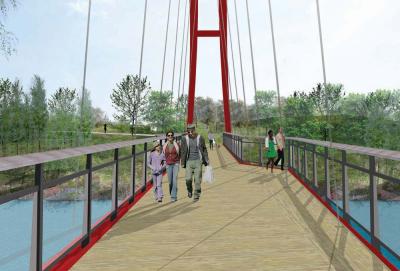
 Bridge over the Neponset: A new footbridge will connect Mattapan and Milton along the Neponset Greenway. Image courtesy DCR
Every summer, Candice Cook leads groups of teenagers through the wooded Neponset River Reservation in Mattapan. Many of the teens, who have gotten work through the city’s summer jobs program, live in the area but they are still shocked by what they see as they clear the brush along the reservation footpath. “Oh, that’s why they call it River Street!”
The Neponset River, the winding and curving waterway that separates Mattapan and Dorchester from Milton on its way to the harbor, is one of the area’s recreational diamonds and a natural resource that activists have fought for more than two decades to make available to the community.
On Monday, Cook, a program manager with Boston Natural Areas Network, and a half dozen state and local elected officials gathered with neighbors and activists at the edge of the reservation to break ground for a new 1.3 mile pathway between Mattapan Square and Central Avenue at the Milton/Lower Mills line.
“This mile is really going to open up the river to the community,” Cook told a crowd of about 50 that included Jack Murray, commissioner of the state Department of Conservation and Recreation (DCR), Maeve Bartlett, secretary of Energy and Environmental Affairs Secretary, Frank DePaola, secretary of the Department of Transportation, state Senators Linda Dorcena Forry and Brian Joyce, state Representatives Dan Cullinane and Russell Holmes, and Vivien Morris of Mattapan Food and Fitness.
When completed in the summer of 2016, the pathway will provide a vital link in the Neponset River Greenway, allowing pedestrians and bikers to travel from the Neponset Valley Parkway in Hyde Park all the way to the Boston Harbor.
“This is not just a walking bike path,” said Morris, program director at Mattapan Food and Fitness. “This is a source of inspiration for all we can have and what we can be if we work together.”
This connection between two neighborhood communities has been two decades in the making. In 1994, Valerie Burns of the Boston Natural Areas Network hosted a charette at UMass Boston to discuss the feasibility of the city reclaiming the state-owned waterfront along the Neponset River. Then, the group went to the state, said Burns. “They said it was an interesting idea, but told us, ‘See if you can build support for it.’ So we did.”
The Massachusetts Department of Transportation will front $12 million for construction of the pathway, and the DCR will chip in another $2.8 million for design and permitting.
The link will feature a “canopy walk” over trolley tracks in Mattapan, an “arched bridge” over the river, several small footbridges, bicycle racks, benches, and a ten-mile trail, among other features, according to DCR. It will also be accessible to users of all ages and abilities.
Rodney Bender, 56, whose Mattapan home overlooks the Neponset, has been pushing for the project for more than two decades. He and many present at the groundbreaking praised the connectivity that will be forged by the path’s completion.
“The biggest hurdle to this all happening,” he told the Reporter, “was the notion or bad reputation that this side of the river has with crime, coupled with folk who may harbor some of the misconceptions about the community.”
Sen. Joyce, who represents Milton, recalled public meetings in the early ‘90s, when some Milton residents feared the pathways could be used as escape routes for robbers. Since then, the Legislature, spurred by politicians on both sides of the river, found money for the first part of the Greenway, which will eventually connect the mouth of the Neponset River with the harbor at Castle Island.
In 2011, Gov. Deval Patrick committed millions to funding the completion, including the missing Mattapan-Milton link. Monday’s event was the last groundbreaking of the Patrick years. “This is one of the best things this administration has done,” Joyce told the crowd.
Phase One of construction is scheduled to be finished by next summer with further work and improvements to be conducted in phases over the next two years, including upgrades at the old Schaffer Paper site in Port Norfolk. The final “missing link” in the Greenway will run north from Port Norfolk to Victory Road, extend around the iconic gas tank in Dorchester Bay, where it will connect with the existing Harbor Walk.
Topics:


