
April 26, 2024
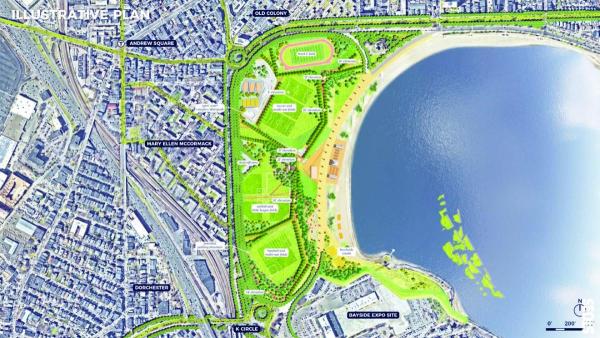
An aerial view of Moakley Park (foreground), Carson Beach, and the surrounding areas included in a city-led "connectors" project. City of Boston image
Officials in charge of a city-led project aimed at protecting Dorchester and South Boston from flood waters associated with rising sea levels will host a pair of public meetings, including an in-person tour, over the next week. And while the two events are focused on the coast along Day Boulevard, they offer an ideal opportunity for city residents to plug into urgent improvements all along our waterfront.
On Saturday, the public is invited to tour the area around Carson Beach and Moakley Park, where city and state officials will offer on-the-spot guidance about the possible infrastructure safeguards that could be built out to keep high-water events from inundating amenities – like Moakley Park – and nearby apartments, homes, and businesses.
The event will kick off from the McCormack Bathhouse at Carson Beach and include four stops along the beach and Day Boulevard between the MWRA facility in South Boston (next to a popular “bark park”) and the State Police barracks by Kosciuszko Circle.
“We’ve set it up as a bit of a self-guided tour with four tables that folks can visit on their own time and get a stamp at each table,” said Hannah Wagner, who is the project manager for the “Resilient Moakley Park Connectors” effort. “There might be prizes and refreshments as well.”
There will also be a follow-up virtual meeting held via Zoom next Tuesday, April 30, at 6 p.m. for folks who cannot make it on Saturday, or to follow up with questions.
All of this is part of a $2.1 million engineering study that is funded mainly by grant dollars steered to Boston by Congress and the Federal Emergency Management Agency (FEMA). With a smaller matching amount from City Hall, the Wu administration is leading the effort and looping in counterparts from the state’s Dept. of Conservation and Recreation and the Mass Water Resources Authority (MWRA), which own critical land along the “flood pathway.”
The scope of this planning effort is around Moakley Park— and points directly north and south— thus the “connectors” name. Wagner says various options to contain flood waters— from berms and retaining walls to other landscaping features— are all on the table, but not yet finalized. That’s the point of this exercise, she says.
“These two meetings are intended to give context and introduce the project and get some high-level feedback,” she said.
The city hopes to nail down its engineering plans by 2026, and have a shovel-ready project that will then need to be funded for a far bigger sum.
This “connectors” project is one, relatively small piece in a complex system of climate resiliency plans underway in this section of the city. Part of the urgency is driven by the reality of climate change and more frequent and disruptive flooding events. But it’s also driven by the imminent explosion in development growth in this area, with Dorchester Bay City – a massive complex of buildings and related road improvements – now approved next door.
Other projects include the sluggish but still-ongoing state-led Morrissey Boulevard Commission, which is also having a meeting next week. The third in a series of commission meetings was moved from this week to Thurs., May 2, at BC High.
Now is the time for local stakeholders to get active and vocal on the coastal front. This weekend’s city-led workshop at Carson Beach offers a helpful and welcome place to get connected.
–Bill Forry
Topics:

