November 26, 2024

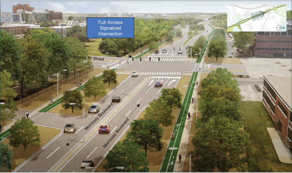
Just north of the Southline building (former Boston Globe headquarters), a new signalized intersection called First Street would be added to connect new development and the existing neighborhood to the waterfront.
A state-led commission charged with accelerating plans for an ambitious and costly re-construction of Morrissey Boulevard called for its work to continue deeper into 2025 during a three-hour public meeting held last Thursday night at the Holiday Inn Express on Boston Street.
Residents and some members of the commission said that the state Department of Transportation (MassDOT) should widen its scope to discuss related projects in more detail—like coastal flood-protection barriers and utility routes—along the Morrissey corridor between Neponset Circle and South Boston’s Preble Circle.
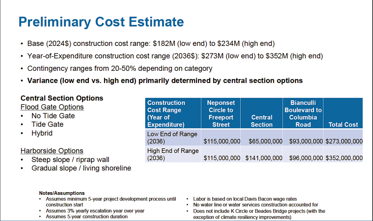
The meeting also offered up the latest budget estimate for flood mitigation and improvements to the roadway, which officials say could now cost between $273 million— on the low end— to $352 million on the high end to build out over a five-year period. Actual construction would not likely begin until five years from now, in 2029 or 2030.
Editor's note: A PDF of the full presentation shown at this meeting is available here.

That price range does not include repairs or replacements of the Beades drawbridge or the usually clogged Kosciuszko Circle rotary.
The commission had already extended its own deadline to offer a report to the Legislature by Dec. 31, 2024. The current timeline calls for a final set of recommendations to be reported after the next public meeting, which is expected in mid-January.
MassDOT’s David Mohler, who now serves as chair of thecCommission, said deadlines would probably be stretched an additional 60 days, but seemed hesitant about extending the group’s purview further.
“The final meeting is going to be beyond mid-January and we’re just going to have to deal with that,” he said. “This has been an interesting and good process, but we don’t want to lose momentum at the end.”
Thursday’s meeting largely focused on design elements of the roadway itself, including new traffic signal schemes, turning lanes, and options to reconfigure the lane system that flows into Kosciuszko Circle.
Much of the curb-to-curb roadway designs, which had been vetted and discussed at previous commission meetings, have been largely embraced by neighbors and commissioners.
“The road is great,” said Commissioner Jake Wachman, a Savin Hill resident appointed to the commission by state Sen. Nick Collins. “Everything else is the problem, particularly an 11-foot wall between Dorchester and the sea. My suggestion is we keep going until we get a better result. MassDOT has a significant responsibility to get this right and it isn’t right.”
The sea wall that Wachman referenced was a frequent point of contention during last Thursday’s meeting, in part because officials have not focused much on the exact placement and design of the wall, which neighbors worry might dramatically change the look of the boulevard and the waterfront.
Councillor John FitzGerald and former Councillor Frank Baker, who serves as a commissioner representing state Rep. David Biele, both want more detail about the wall idea.
Savin Hill Andy Donovan spoke for many at the meeting when he said: “I’d like that wall to be as minimal as possible, so you don’t wall us off from the ocean and prevent us from getting to the ocean. We live here because we want to be near the ocean. We don’t want to live behind an 11-foot wall.”
Other concerns raised by members of the public include worries that public utilities— like electricity and sewer lines— are not sufficiently plugged into the planning process.
Don Walsh, a longtime Savin Hill resident, said he would like to know how the estimated 10,000 new housing units being built-out in the Morrissey and Dorchester Avenue corridor adjacent to Savin Hill will impact existing homes. He thinks more time should be spent on those details before the commission ends its work.
“I was encouraged by what was on paper for this commission, but not by what actually happened,” Walsh said. “I say we forget about deadlines. Let’s not worry about December, or January. Let’s worry about doing it correctly.”
Barney Carney echoed Walsh’s comments.
“The road, the obvious thing was dealt with,” Carney said. “If one were to choose to think way outside the box, you would go further than transportation in thinking about what comprehensive planning means.”
These sentiments came after MassDOT officials worked their way through an 88-slide presentation about the roadway over two hours.
Kairos Shen, the city of Boston’s new planning chief who attended the meeting — his first as a commissioner— said he also favored more comprehensive planning.
Mostly, the meeting focused on the road, with the state showing the first renderings of possible changes to Kosciusko Circle, which is a separate planning process likely to start next spring. Some of the initial concepts there included diverging diamond entries to the Southeast Expressway with a modern roundabout or signalized intersection at the circle.
Neponset Circle was one of the few places where alternative designs didn’t seem to make congestion any better. Studies used to inform the commission’s work show back-ups from I-93 and the Neponset River Bridge will nearly double the traffic and pedestrian delays at the Circle, though westbound traffic will find new relief.
At Freeport Street, a new design eliminating left turns and implementing a new signalized intersection at Victory Road has been chosen and is expected to increase east-west connections between the waterfront and the neighborhood. The entryway to Bianculli Boulevard (by UMass Boston) would be re-designed to reduce lanes and add an acceleration/deceleration lane at Old Colony Terrace, a change that planners say would drastically reduce delays for motorists.
Just north of the Southline building (former Boston Globe headquarters), a new signalized intersection called First Street would be added to connect new development and the existing neighborhood to the waterfront.
Finally, Preble Circle would become a signalized intersection instead of a rotary as it is today.
FitzGerald argued against adding bike lanes on the road in both directions as the new Neponset Greenway runs adjacent to the project. Instead, he has called for a dedicated bike lane to be sited along the new ocean wall, or berm, and connected to the new Greenway terminus near Beades Bridge.
“I don’t want to be duplicative when there is already one there,” he said. “I think it’s safer and already under construction.”
For more details — and the complete slide-deck from last Thursday night’s meeting, see dotnews.com.
| Attachment | Size |
|---|---|
| 7.35 MB |


