August 14, 2024

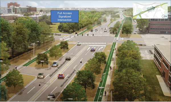
A rendering shown during last week’s Morrissey Commission meeting depicts a revised lane configuration and a new “1st Street” that would bisect Morrissey Boulevard near BC High. MassDOT image
Members of a state-led commission charged with redesigning Morrissey Boulevard reviewed additional alternatives for the roadway system during a hybrid meeting held at Boston Collegiate Charter School on Sydney Street last Tuesday (Aug. 6), where much of the discussion centered on how to reconfigure traffic patterns around the entrance to UMass Boston and how to allow for better east-west connectivity for Savin Hill residents.
“This is a Dorchester neighborhood cut off from the waterfront my entire life,” said Frank Baker, a commission member and former District 3 councillor. “The connections east and west are very important. I think…Local traffic should weigh heavier than traffic south or north…I’d like to see more about how we get east to west in a real way. That means how do we get there pushing a baby carriage?”
The meeting – the fifth in a series that began last November – is the first since the group voted to extend its work to the end of the year, adding four meetings with a final report to the Legislature due by Dec. 31.
The extension has allowed Massachusetts Department of Transportation (MassDOT) officials more time to present alternatives for five key areas along the corridor – including Preble Circle, 35-75 Morrissey Boulevard, Bianculli Circle/Old Colony Terrace, Freeport Street/Victory Road, and Neponset Circle.
Another key section – the Kosciusko Circle (K-Circle) rotary – will be considered under a different design process that is now set to start in the fall.
“We can now dig deeper into the alternatives, and we didn’t want to bring any of them along too far yet,” said MassDOT project manager Ethan Britland. “We see here tonight that most alternatives function, some better than others, but generally none function worse than the existing infrastructure in future conditions.”
The computer analysis for each of the alternatives was done under two assumptions: there will be two lanes of traffic, and bike lanes in each direction.
“The model shows a major shift back to ’93,” said Britland, referring to the Southeast Expressway. The models, he said, account for at least 13,000 new housing units along the corridor. Some in the audience pushed back on the notion that I-93 would be an alternative route, with one person calling it “the biggest parking lot in New England.”
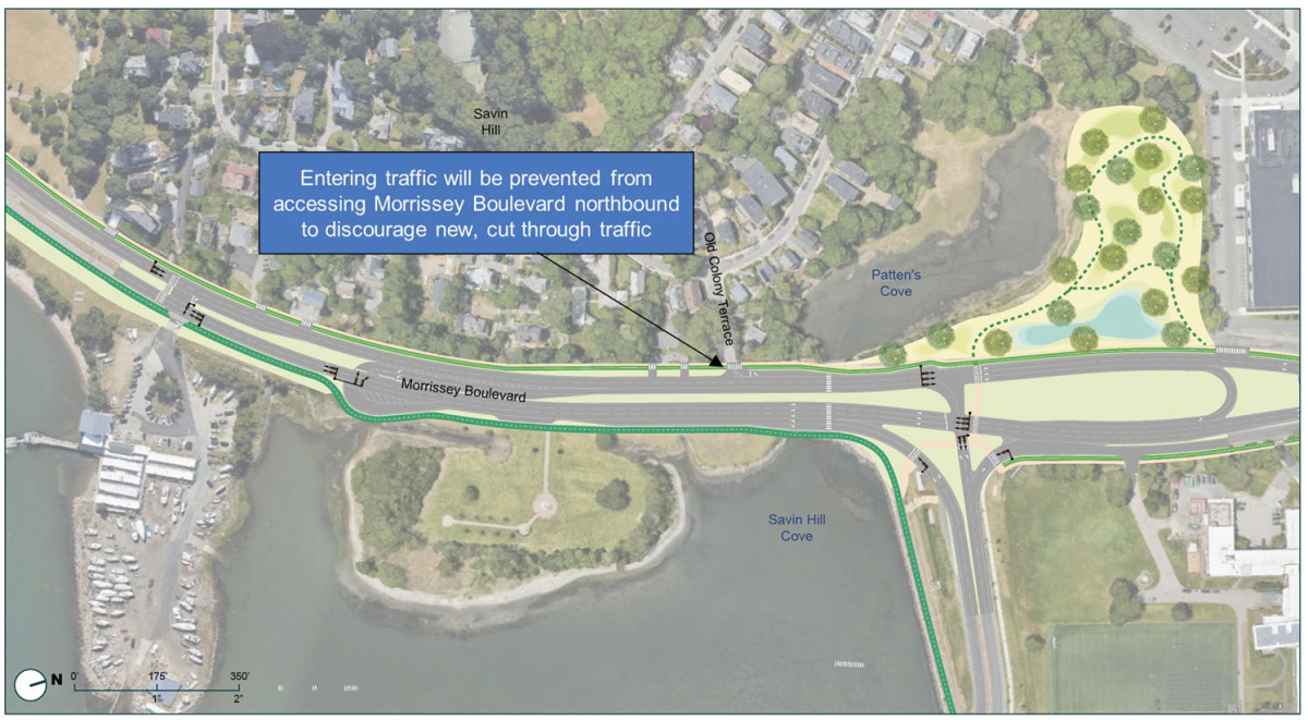
Much of the dialogue at the meeting focused on where to add U-turns along the parkway, specifically along the stretch near UMass Boston’s Bianculli Boulevard and Old Colony Terrace, which allows access to and from the Savin Hill neighborhood.
One design showed a U-turn in front of the Vietnam Veterans Memorial, which state Rep. Dan Hunt, a commission member, said would be a problem. “It seems to not allow the Savin Hill community to have access from Old Colony Terrace. The previous U-turn [in an earlier design] was in front of the Yacht Club, and I thought that was still the case. Going northbound, to make a U-turn after Freeport Street – you’ll be fighting traffic and never get out and never get to Freeport Street.”
Councillor John FitzGerald was also upset about that design element, as was Savin Hill resident Jake Wachman. Both are members of the commission.
“That U-turn [at the Memorial] is not what we wanted and other people here are aware of that,” he said to applause from the crowd.
Later, he and others asked MassDOT if there could be a design that incorporated a turning lane into Old Colony, an acceleration lane out of Old Colony, and moving the U-turn to the area of Dorchester Yacht Club.
“Is that still on the table?” Wachman asked. “It is on the table; we did test it in the alternatives,” said Britland.
Another key focus for designers is 35-75 Morrissey, where a major building development is slated to rise from the old Channel 56 property. MassDOT proposed a new ‘1st Street’ there that in one alternative introduces a new signalized intersection promoting east-west connections from Savin Hill to Columbia Point.

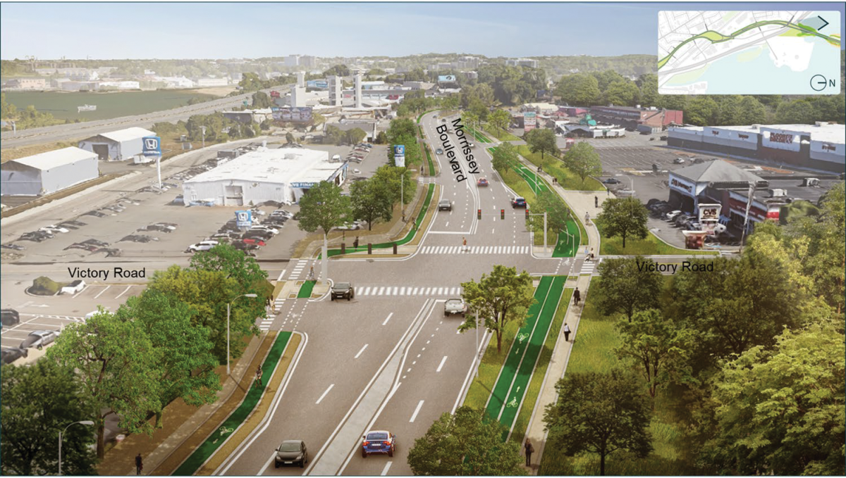
Above, a rendering shows a view looking south along Morrissey Blvd. and a potential new traffic signal at Victory Road. Below, a slide from a MassDOT images

The signalized intersection is about one-quarter of a mile from K-Circle and would slow down traffic and remove the service roads that now parallel along the boulevard.
A new configuration for Freeport Street and Victory Road was also presented to mixed reactions, but not much discussion. The best performing alternative eliminated all left turns at Freeport Street and created a new signalized intersection and U-turn at Victory Road. That would allow more connections from the neighborhood to the waterfront and the upcoming Neponset Greenway and eliminate the confusion existing now with turns.
Other options included:
•At Preble Circle, options were to improve the existing roundabout, or to create a new signalized intersection, which seemed to get the best results.
•Neponset Circle would not see many changes as it is limited by the I-93 on ramp and traffic coming from Gallivan and going over the bridge to Quincy.
•K-Circle, while critical to Morrissey Boulevard operations, is on a separate planning track, according to MassDOT’s Britland, who said: “It’s a separate project and the reason is it’s further along than we are…The project team will be going out in the fall to engagement with the public.”
The next commission meeting will focus on connectivity, specifically pedestrian and bicycle plans – with neighbors requesting that the conversation about cars be limited in that meeting as they are most interested in pedestrian experiences. Computerized visual simulations on the corridor will also be displayed at a future meeting.
“After we produce our key findings, then the commission would vote or approve,” Britland said. “That vote really would essentially decide what goes to the Legislature under our mission.”
Arthur Jemison, the planning director for the city who recently announced his resignation, was not at Tuesday’s meeting, and city officials are looking into who would replace him in time for the year-end vote.


