July 2, 2024
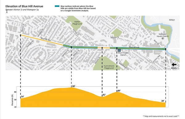
Image showing Blue Hill Ave. elevations courtesy Jack Halverson, Planner II, BPDA, City of Boston
Five years ago, I began taking weekly walks on Blue Hill Avenue for the purpose of seeing the state of anything and everything for public services, streetscapes, types of businesses, housing types, who is walking or using walking-aids/wheelchairs, biking, trucks, cars, scooters, buses, and its physical appearance. My roundtrip route takes me across Cummins Highway, crossing both sides of Blue Hill Avenue, from the front of the Brothers Deli & Restaurant at Mattapan Square to the Madhouse Cafe at Dudley St and Blue Hill Ave (9 miles) and back to my starting point. I have walked alternative routes where I follow the outline of the Greater Mattapan Zoning Boundaries, which is about 10.6 miles.
This avenue is named after the Blue Hills we see in the distance beyond Mattapan Square. The rises and falls of this road are obvious to anyone who walks or drives its length. I can see the Boston skyline with the Prudential building above the tree lines. At points, the hills obscure my view of the city. This continues as I make my way through Grove Hall and finish my walk at the Madhouse Café. The same rise and descent of the road is obvious to anyone walking the opposite direction.
Heading south at Franklin Park, I can see the Blue Hills, but walk six blocks and they fade just as the Boston skyline appears, a pattern repeated the length of the avenue.
It’s clear to both pedestrians and drivers that Blue Hill Avenue is a series of hills and valleys, and this has a significant effect on how people drive, often without appropriate caution. Considering the road surface when debating bus lanes, bike lanes, and pedestrian crossings is crucial for both safety and in providing a steady travel speed, for pedestrians and drivers.
Using the Blue Hills visibility as the measure, does the road design support a constant posted speed limit (25 mph), or does the design encourage drivers to exceed it? Have there been community discussions about signage to indicate when the road surfaces climb or descend?
We are all well aware of the excessive speeding on Blue Hill Ave; but I cannot recall one conversation about the extreme elevations on it. This discussion should be part of the next phase of community engagements about the Blue Hill Ave Transportation Action Plan.
For this project to be successful, it is important for the design to consider its surroundings and respect it. Contextual elements like the community and environment that surround the area should determine fundamental design decisions, such as the cross-section determination, detailed design elements, and street fixtures.
I reached out to the BPDA Planning Department’s Kathleen Onufer, deputy director of Zoning, and Jack Halverson, Planner II. I explained my thoughts about the lack of discussion about the elevations of Blue Hill Ave when discussing zoning codes’ effectiveness and to explore the extreme elevations of Blue Hill Ave, driving speeds, and lack of safety.
I asked if I might work with Mr. Halverson to plot these variations in the visibility of the Blue Hills. The work could be used by others and perhaps spur deeper community conversations to solve planning and design issues related to spatial equity, architecture, and design.
As drivers travel through Mattapan Square, they face an incline of approximately 42 feet until they get to the Blue Hill Avenue commuter rail station. Continuing along from there is a constant up and down rollercoaster that drivers may be unaware of, caused by more than the poor road conditions. Adding road grade variations through texture, bioretention swales, wayfinding, and art installations will address excessive speed as well as encourage drivers to stop and maybe shop or explore the area.
The Blue Hill Avenue Transportation Action Plan is set to begin in 2026. There are streetscaping design elements that should be recommended to help with travel speed rates. The Boston Transportation Department and the MBTA have a block-by-block survey for community stakeholders in the next phase of this Transportation Action Plan. I applaud the effort of asking responses for each block. But what is absent is the necessary language to describe the types of streetscapes that enhance safety and provide a pleasing, identifiable, and cohesive aesthetic that encourages multimodal travel, bioretention, placemaking, wayfinding, and art installations that have a relation to the area.
Without the necessary language and visual cues, residents are not likely to request amenities that also are visually appealing and address the need for safe multimodal movement on Blue Hill Avenue.
Solution 1 – There should be a choice for adding more e-Bluebikes than regular Bluebikes, because of this avenue’s elevations. This is an equity moment, providing a public need that would improve local stakeholder experiences. It is more appropriate here than on roads that are not as long and do not have significant elevations. Present additional information that connects all parts of Blue Hill Avenue within environmental, historical, and cultural context.
Solution 2 – Entering Mattapan Square should not be a fleeting moment. Wayfinding signage and arts installations, bioretention swales with and without seating; trees and lighting that change with the season. All of these types of changes will slow down the speeding on Blue Hill Ave and improve public health and safety while providing an aesthetic that embraces this community’s natural features.
“Mattapan is a good place to be…Greater Mattapan just keeps getting better.” This is the tagline of the Greater Mattapan Neighborhood Council. We want our community to not only look good, but to make you feel good. As David Lopes, an original GMNC Board member, told me: “No one should feel visually assaulted in their own community.” Yet this is exactly what is occurring for those of us who live or work in proximity to Blue Hill Avenue. And it does not have to be if we want better.
The author is the chairperson of the Greater Mattapan Neighborhood Council.