June 12, 2024

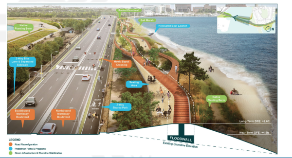
A rendering of a potential re-design for Morrissey Blvd. Mass DOT image
Members of the Morrissey Commission held a community meeting on Monday (June 10) hoping to arrive at consensus decisions on some of the design alternatives presented by MassDOT for the rehabilitation of the Morrissey Boulevard corridor. The session, organized and moderated by City Councillor John FitzGerald, was held in the boulevard’s Southline Boston building and attracted about 40 people.
“We’ve sat through the MassDOT presentations, we’ve seen them at length now,” FitzGerald said at the top of the meeting. “We heard some folks in the community say, ‘Why don’t we just huddle up on our own so when we come to the next meeting, we’ll have a better message to communicate?’”
The original intent of Monday’s meeting was to brief the public on design alternatives so that people could come prepared with more informed presentations at a fourth meeting of the commission. However, that fourth meeting took place virtually on May 31, and members voted then to extend their deadline for the final preferred design from June until the end of 2024.
The fifth meeting of a series that started last November is now expected to be held in July. Monday night’s session featured city and state officials poised to take attendees’ questions, including MassDOT project manager Ethan Britland, representatives of City Councillor Erin Murphy and of state Sen. Nick Collins, as well as representatives from the Boston Planning and Development Agency and the the Boston Water and Sewer Commission.
Additionally, two listening sessions were planned for Wednesday of this week – a virtual listening session in the afternoon and an in-person walking session along the corridor at 5 o’clock.
FitzGerald led attendees through slides from a commission meeting held on May 3, where the boulevard was divided into three sections: the north zone, from South Boston’s Preble Circle to Bianculli Boulevard at the entrance to UMass Boston; the central zone, from Bianculli Boulevard to Freeport Street; and the south zone, from Freeport Street to Neponset Circle. Attendees were invited to give their thoughts on each design proposed from that presentation.
On the north zone, many attendees reiterated that they were concerned about the lack of knowledge about the status of the redesign of Kosciuszko Circle, and that their feelings on the rest of the north section would probably be informed by those plans. Britland said the first community meetings for that project — a separate study, according to MassDOT officials, that began prior to the formation of the Morrissey Commission — would likely be held sometime this fall.
However, the road that runs under K Circle and in front of JFK/UMass station, according to Britland, is in fact partof the current project’s domain, though specific renderings of this area have yet to be presented to the public.
Some attendees suggested that the only fixes to Preble Circle in South Boston should be more pedestrian safety measures. For the stretch of road between Preble Circle and K Circle, they preferred the design with narrower bike lanes and no bus lane, since that area doesn’t have too many buses on it, as of now, anyway. Most, though not all, participants preferred designs that eliminated the frontage roads for the stretches of road in front of BC High and the old Globe headquarters. For the final stretch of the north zone, the Bianculli Boulevard intersection, attendees overwhelmingly preferred the “continuous green light” alternative for the far right lane heading south.
As to the central zone, commissioner Jake Wachman requested that new renderings be presented that would show what the proposed berm would look like to pedestrians. MassDOT has said that a berm of at least 6.5 feet would be needed to defend the road against the worst-case-scenario projected flooding by 2070.
Community member John Rich wondered about maybe creating a viaduct instead of a berm, which would also improve the health of the bay. For his part, FitzGerald thought it would be better for the proposed bike lanes to be on the berm instead of on the road, giving bikers a scenic route and freeing up more room on the parkway.
Creating a tide gate at Beades Bridge, also a separate MassDOT project, came up for discussion, but it would likely mean the bridge would no longer have drawbridge capabilities. The progress on this project, said BPDA representative Joe Blankenship, is still in its very early stages.
For the southern zone, there were mixed opinions concerning a redesign near the Freeport Street intersection, though some support was shown for a median U-turn design. Wachman said the funds that would go toward placemaking design planned for Neponset Circle — including signage, vegetation, and public art — might be better spent somewhere else in the project’s budget, calling this design “icing.”
More information about the Morrissey Commission and the Morrissey Boulevard project can be found at mass.gov/info-details/morrissey-boulevard-commission.


