May 12, 2023

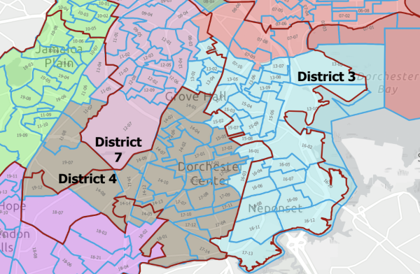
Part of the map proposed by Mayor Wu. The maroon line marks current districts and the colors mark what’s proposed.
Mayor Michelle Wu on Friday evening released her effort to redraw the lines of the City Council’s nine district seats, coming days after a federal judge nixed a previously enacted map and upended Boston’s political sector. The map unites Dorchester’s Ward 16 entirely within District 3, currently represented by Frank Baker, who is not running for reelection.
Note: A full version of the mayor's proposed map is attached to this article in PDF form.
Wu urged councillors to take up the map, or an amended version, at the next City Council meeting, scheduled for Wednesday, May 17. Taking action by that date will allow for “sufficient review and potential rejection or amendments before the May 30 deadline,” she wrote in a letter to the Council.
May 30 is a crucial date, because the Wu administration considers it the latest possible date that allows the city’s elections department to conduct a signature petition process, certify signatures, and print and mail ballots in time to conduct the planned Sept. 12 preliminary.
Wu has also filed a home rule petition — which requires sign-off from the Council and the state Legislature — that extends timelines for filing nomination papers and offers clarity on counting voter signatures that have already been submitted.
Her map will be filed with the city clerk on Monday morning, a Wu spokesman said. “This proposed map unifies neighborhoods within council districts and is one that I am prepared to sign,” Wu wrote.
The map does attempt to unite neighborhoods across the city, give or take a few precincts. Fields Corner, Neponset, and Uphams Corner would all be in District 3, and the map keeps South Boston entirely in District 2 (represented by Ed Flynn) while sending South End into District 8 (vacant seat previously by Kenzie Bok). Meanwhile, District 8 would lose Mission Hill to District 6 (represented by Kendra Lara). Roslindale is also mostly united within District 5 (Ricardo Arroyo).
The Wu map moves more of Mattapan into District 4 (represented by Brian Worrell), but the Haitian residential community would be in Hyde Park-based District 5, in an effort to connect it with a growing Haitian population there.
The Council’s Committee on Civil Rights, chaired by Councillor At-Large Ruthzee Louijeune, is set to meet on Monday and Tuesday, both days at 2 p.m. inside the Iannella Chamber, to hash out a map.
The placement of Ward 16 completely within District 3 may hearten Dorchester’s Adams Village and Neponset neighborhoods, home to white conservative super-voters who were split apart by the map that passed the Council in a 9-4 vote last fall.
Last fall’s map quickly drew a legal challenge, which landed in federal court. Backed by local civic groups and funded by the four councillors who opposed the map (Baker and Flynn, who is also the Council president, and Councillors At-Large Michael Flaherty and Erin Murphy), the lawsuit argued in part that race wrongly predominated redistricting discussions as the map sliced up Adams Village and Neponset.
US Judge Patti Saris on Monday ruled that the lawsuit had a likelihood of success on that argument, blocked the enacted map from going into effect for this year’s municipal elections, and ordered councillors make another attempt at drawing district lines.
The redistricting process occurs every ten years, after the US Census. The problem at the center of this redistricting effort has been a population boom in District 2, meaning it had to lose population, while District 3 lost population, meaning it needed to gain residents.
Along with uniting Ward 16 overall within District 3, Wu’s map’s placement of Ward 16-Precinct 1 in the district brings together the Vietnamese community in the Fields Corner neighborhood, something that most proposals last fall also attempted. If enacted and upheld, that also allows Joel Richards, a District 3 candidate, to keep running, since under the previous map passed in 2012, he was in District 4 and had waged a campaign for that seat in 2021.
All of Ward 13 would also be in District 3, stretching west to east, from one precinct with Blue Hill Avenue as a western boundary, to the UMass Boston campus on the east side.
The Wu map also has District 2 come down to Moakley Park and Columbia Road in the Columbia-Savin Hill neighborhood. That would also keep South Boston public housing developments whole, something that the people behind the redistricting lawsuit were looking for.
Hours before the release of Wu’s map, the Lawyers for Civil Rights, representing a coalition of voter advocacy groups, including some that defended last fall's map, urged City Hall leaders to focus on “limited” changes between Districts 3 and 4 and to keep everything in the public eye. They also urged swift action to “avoid voter and candidate confusion in the upcoming election.”
The coalition includes NAACP Boston Branch, MassVOTE, the Chinese Progressive Association, and the Massachusetts Immigrant and Refugee Advocacy (MIRA) Coalition, among others.
“Although City officials enacted that map following an extensive public process, local political insiders disgruntled with the result bankrolled litigation to invalidate it,” the coalition said in a statement, in a reference to the four councillors who helped fund the federal lawsuit.
“The Boston City Council must provide all Boston residents with an opportunity to have their voices heard in redistricting,” the statement added. “Failure to do so will erode democracy and create additional barriers to equitable representation in Boston.”
| Attachment | Size |
|---|---|
| 1.08 MB |


