
January 12, 2022
Transportation was the key topic of the most recent Dorchester Bay City development meeting on Jan. 10.
Meetings focused on the massive Dorchester Bay City project at Columbia Point kicked off on Monday of this week, with one of the main issues involved in the development – transportation – on the agenda.
How people will move around the new neighborhood is top of mind for close watchers of the project, as the site sits close to a number of areas waiting for upgrades, including Kosciuszko Circle (K Circle), Morrissey Boulevard, Mt. Vernon Street, and the JFK Red Line Station.
The developers Kirk Sykes and Dick Galvin, of Accordia Partners said they plan to contribute financially to those transportation issues, but they mostly hope the project will be a “catalyst” to bring everyone together to solve the bigger problems.
“Part of our charge was to put together a game plan, to be the convener or catalyst to see these big partners come together with solutions on transportation,” said Galvin.
To that end, both said they have already been meeting for a year with a working group led by the Massachusetts Department of Transportation (MassDOT) and involving eight city and state agencies focused on what is known as a Regional Transportation Demand Model (CTPS) – a planning tool that anticipates all new developments, housing units, and transportation trips through 2040.
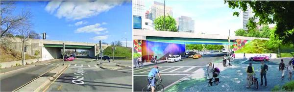
Galvin and Sykes said that work will be the underpinning for a large state and city transportation study of K Circle and Morrissey Boulevard that is to begin later this year.
“We have been meeting for the better part of a year now to understand how the city and state can work to make these solutions come to bear,” said Sykes.
They hope to light the spark that can leverage public money from sources like the recent federal infrastructure investment and jobs act, and private funding from other developers in the immediate area.
Such a strategy, using a large project as a catalyst, was employed about six years ago on Rutherford Avenue in Charlestown – a similar stretch used as a secondary commuter roadway – with the Encore Boston Harbor casino project acting as that catalyst. That effort yielded detailed plans for the area, and that project is funded and scheduled for construction next year.
The hope is such a process can repeat for the K Circle, Morrissey, Mt. Vernon, and JFK quadrangle, and Dorchester Bay City, for its part, indicated it planned to make a $26.7 million commitment. That money would be for designing, permitting, funding, and constructing transportation improvements. But 66 percent of that commitment, or $17.7 million, will be reserved for use during Phase 1 of the Dorchester Bay City project to construct a new Mt. Vernon Street layout to meet the city’s Complete Streets standards.
The most recent cost estimate for Mt. Vernon Street is $15 million, with K Circle at $200 million, Morrissey Boulevard at $40 million, and the JFK Station renovation at $100 million.
“Most of the solutions are right there in front of us,” said Galvin. “We’ve talked about them for years. Our strategy is to confirm these strategies and solutions and provide early dollars…starting with Mt. Vernon Street as our first improvement and putting out money early to help advance the JFK Station, Morrissey and K Circle and make these projects…’shovel worthy.’”
Galvin added that the remaining money from Dorchester Bay City would be under the purview of the city and the project’s Community Advisory Committee (CAC).
Transportation planner Lourenco Dantas, who is working on the Dorchester Bay City project, said that by reducing parking substantially, they believed that most trips would come via walking and public transportation. The shares of trips coming by public transit at morning are expected to be at 37 percent, and 27 percent in the evening. Pedestrian trips would account for 24 percent in the morning and 34 percent in the evening, according to Dantas. With upcoming Red Line train car and signalization upgrades, their analyses showed that there would be enough capacity on the Red Line to handle the project’s increased transit trips.
Another strategy for limiting traffic, Sykes and Dantas said, is not building the allowed number of parking spaces. They are building 2,865 spaces at the full buildout, while they are allowed 3,600 slots. The existing parking on the site now consists of 2,338 spaces.
During the comments from the public, Steve Hollinger said he felt the plans were very “car-centric,” especially with roadways that were 53.5 feet wide and “ridiculous for a floodplain and a city trying to build density.”
Neighbor Desmond Rohan said he had major reservations about the larger transportation issues like K Circle and needed “assurance of action there.” “We’ve seen this show before,” he said.
David Butler, of the Columbia-Savin Hill Neighborhood Association, said he hoped that the approach would work, but he felt the plans didn’t reflect how gridlocked the area is now.
“I think you’ve understated how quickly the whole neighborhood gets gridlocked,” he said. “It’s great that you’re fixing Mt. Vernon, but all those streets have chokepoints.”
The next topical meeting for Dorchester Bay City will focus on housing and economic development and will be online on Thurs., Jan. 20, at 6 p.m.


