
November 18, 2020
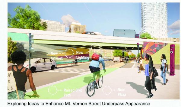
A rendering shows a re-imagined Mt. Vernon Street underpass near JFK-UMass station. Image courtesy Accord Partners
Stakeholder buy-ins seen as crucial
Some 100 people logged on to a virtual meeting on Monday as the principals from Accordia Partners LLC delved into transportation and infrastructure specifics for their massive Dorchester Bay City development along the Columbia Point waterfront.
Hosted by the Boston Planning & Development Agency (BPDA), the session was the fifth in a public engagement series that has reviewed elements of the plan to transform the 34-acre waterfront site into a new community with a mix of housing, retail, and public space.
Designers from several architectural and engineering firms discussed the project’s multi-modal street design and resiliency measures while Accordia principals Dick Galvin and Kirk Sykes went over the on and off-site infrastructure investments that will be needed to support a new 18-block neighborhood.
“We have some big ideas for Dorchester Bay City,” said Sykes. “One of our goals is to create new corridors and walkways from the community and transit to the Harborwalk, and for each of those pathways to have its own character and make it exciting for everyone.”
He added: “We’re also excited to be accessible by the T, pedestrian, and bike-centric paths. Hopefully the last thing people think about is coming by car, but we will also have accommodations for that.”
The JFK-UMass MBTA station, Mt. Vernon Street, Morrissey Boulevard, Day Boulevard, and Kosciuszko Circle are where key off-site infrastructure improvements must be factored into the Accordia team’s plans.
“In earlier conversations with all of you it became clear that we could use this project as a platform to realize some of the improvements that have been talked about and studied over the past several years,” said Galvin. “Our strategy is to try to unlock support and funding for these infrastructure projects through a series of coordinated public and private partnerships that would include ourselves, the city of Boston, state agencies, etc. to move these discussions forward.”
He continued: “We have a long way to go, but part of our commitments would include that we would fund the design and construction of the Mt. Vernon Complete Streets project, and we would fund preliminary design work associated with the other projects referenced to help position them as ‘shovel ready,’ which will help attract public monies for that project.”
Christian MilNeil was one of several people on the call who asked specifically about the uncertain status of Morrissey Boulevard re-design project.
“I’m very curious about what’s going on. … Nothing has happened since they reached 20 percent design in 2017. I’m curious to know whether BPDA and the developers have been trying to revive that process,” he said.
Galvin replied that the goal is “to ignite the conversation with all of these stakeholders to advance the plans and bring them up to speed in terms of where we sit today in 2020 and beyond.
“We’re really getting those conversations going. …That’s probably as far as we can take it tonight,” he said.
Ted Shwartzberg, a senior planner at the BPDA, noted that Morrissey Boulevard “fundamentally serves as a barrier from the JFK UMass station” to the Bayside site.
“It’s a facility that’s owned by state agencies – MassDOT and DCR,” he said.
“We know the development team is working closely with them and it’s incumbent to ensure that if this project is to go forward that there are adequate and proportionate interventions to improve Morrissey so that it no longer acts as a barrier but as a gateway for the rest of Dorchester and the Red Line into this site.”
Added Joe Blankenship, a member of the BPDA’s transportation team: “There is a 25 percent plan for Morrissey Boulevard that exists and is on the shelf. There’s been a lot learned in the last few years relative to climate resiliency and what would or would not need to happen on Morrissey in terms of elevation.”
Blankenship said that major coordination related to this site would include Day Boulevard as well.
“They are all related to the design and status of redesigning and reconstructing Morrissey,” he noted. “So, the state, city, and other agencies are beginning to closely coordinate on a larger effort to look at all of those big projects holistically. This is one that is sparking and pushing that conversation along, and we’re hoping to continue to make progress on it.”
At that point, At-large City Councillor Annissa Essaibi George said, “I am happy to explore ways to support [state agencies] being more at the table.”
Added Galvin: “What’s clear, we hope, is that you’ll see site infrastructure, resiliency, road networks are all much more interrelated now than they’ve ever been.”
In terms of the impact on traffic on nearby roadways, Lourenço Dantas, senior transportation planner at VHB, said the project “would be leveraging the new, robust, and emerging pedestrian and bicycle connections to link the neighborhood.”
Dantas also pointed to the MBTA’s commitments to investment in Red Line improvements— which include signal upgrades allowing for more frequent service, and passenger capacity growth by 2024.
Some attendees, however, raised concerns about the MBTA’s most recent proposal to cut service in the spring due to covid-related funding gaps.
“The next step is to study the traffic impacts on Mount Vernon Street, Columbia Road, Day Boulevard, and Morrissey Boulevard and understand what those additional vehicle trips will add,” said Dantas.
The last topic-specific Dorchester Bay City meeting will be held on Thurs., Dec. 2 with discussions about housing and economic development. The BPDA will then review comments and Accordia will be required to submit a scoping determination and filing of a draft project impact report, all of which will kick off another series of public meetings.


