December 3, 2020

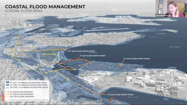
In the fourth and final public meeting on a massive re-design of Moakley Park last week, discussion centered on climate resiliency plans for the 60-acre park and surrounding neighborhoods. About 170 people participated in the online “Moakley Talks,” a sequence of meetings held over the last month meant to give the public a look at still-evolving city of Boston plans to simultaneously improve the park and create a waterfront buffer against the threat of rising sea levels and flooding.
Many elements outlined in a 2018 vision plan remain in the latest iteration, including four major sports and athletics fields at the park’s core surrounded by trees and new paths and spaces for events and markets. It also posits a number of new facilities and additional parking, restrooms scattered throughout the park, and community buildings operated by a full-time maintenance staff.
The project, by the city’s latest estimate, could eventually cost in excess of $240 million over more than a decade of work. Allison Perlman, project manager for the city’s Parks Department, told attendees that the plan could be ready for “Phase 1” construction in two to three years.
“I would say we have around another two years for design and after that we have construction,” she said. “That is really going to depend on funding sources and we’re thinking that it will be a phased construction over time. We’re thinking that Phase 1 will start in 2 to 3 years and then we’ll continue to build over a 10-to-15-year period.”
“I think in our minds if we could build it all at once that would be the best way to do it, but we have to be flexible and take advantage of different opportunities that come up,” Perlman added. “We also want to balance out the construction with existing usage so we can make sure that people still have access to the park.”
The city-owned park is surrounded by stateowned assets— Carson Beach, Kosciuszko Circle, Morrissey Boulevard, and Old Colony Avenues— that will require buyin and coordination from state officials.
“The city only owns the park itself,” Perlman said. “We don’t own the surrounding streets or roadways, so we can really only advocate for change there.”
Environmental concerns have been a key driver of the Moakley re-design since the Parks Department kicked off its planning process in 2018.
Some of the concerns identified by planners and community members over the last two years include coastal and stormwater flooding and the “urban heat island effect” that comes with higher summer temperatures.
Improving access and safety for pedestrians and bicyclists have also been key planks in the design effort.
Preliminary design features of a reconstructed Moakley would mitigate coastal flooding and storm surge by creating “coastal landscapes,” including berms, stormwater gardens, porous pavement, underground storage systems, and tree trenches. Experts hired by the city have projected a sea level rise of as much as 40 inches by 2070.
To address the concerns, measures include doubling the current tree canopy in the park and implementing other shading structures as well as water and cooling systems.
Amy Whitesides, studio director at Stoss Landscape Urbanism, said the social benefits of the design are tied in with its resilience structures. For an example, she pointed to the “dual purpose roles” of areas along the side of Moakley Park closest to Day Boulevard and the beach, most notably an amphitheater space.
“The area creates a highpoint in the park which is functioning as an amphitheater on the water side, and in coastal storm conditions the same place really serves as the barrier,” she said.“So, we’re being protected by this on the backside from the storm surge, but on a day-today basis this space is really about social function and connection to the community.”
Julie Eaton Ernst, lead resiliency engineer at Weston & Sampson, highlighted the team’s proposed environmental strategies, which a few of the planners said would include a holistic approach.
“We’re really looking at implementing these strategies throughout the park— it’s not one individual feature. It really works together as one large integrated system and it’s all a big part of how Moakley Park is evolving in the future,” said Eaton Ernst.
The team hopes to increase connections to the city’s existing and proposed bike routes and make improvements to bike lanes along Old Colony and Day Boulevard, according to Whitesides.
“We will be working with MassDOT and the owners of those roads so that we can continue to look at how we can make sure they’re safe,” she said.
Added Perlman: “We still have a little more design to do, as you can see it’s still pretty high level. We’re going to move into a schematic design and we have a lot of permitting to do.”


