
November 27, 2019
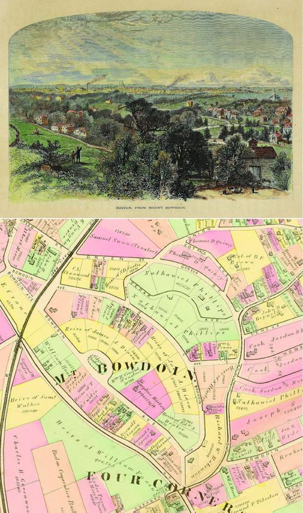
A scan of wood engraving published in “Picturesque America.” By William Cullen Bryant. New York: D. Appleton & Co., 1872-74. Hand-colored.
Reprinted with permission of Dorchester Historical Society.
The view is probably from the land owned by Nathaniel Phillips. The highest points of land on the hill are along Bowdoin Avenue. Boston is shown in the distance, with the Massachusetts State House just left of center. The body of water in the center of the illustration is the former South Bay, at that time a body of water that rose and fell with the tides as the sea water flowed through what is now the Fort Point Channel. There is railroad trestle crossing the South Bay, and that line of tracks was the early version of the Fairmount Line. At the far right, First Church stands on Meetinghouse Hill.
Mount Bowdoin is one of the hills of Dorchester. The Boston Landmarks Commission’s area form for Mount Bowdoin, dated 1995, reads:
“Mount Bowdoin was named for James Bowdoin, the Revolutionary War patriot and governor of Massachusetts during the late 1780’s. As early as the mid 18th century. Gov.Bowdoin summered on Dorchester’s Mt. Bowdoin, or Bowdoin Hill as it was originally known. He was undoubtedly attracted to the panoramic views of the harbor and Blue Hills visible from atop the hill that would be named in his honor.
“The Bowdoin House was located at the crest of a secondary hill projecting from the lower southern slopes of Mt. Bowdoin. In fact, Bowdoin Avenue started out as a two-pronged driveway leading up the hill from Four Corners (Bowdoin, Washington, Harvard streets intersection) to the Bowdoin house. The western “arm” of this driveway continued northward past Bowdoin’s residence and over the Mount’s upland pasture. This road represents present day Bowdoin Avenue. The eastern “arm” of Bowdoin Avenue ran directly past the governor’s house and was renamed Rosseter Street during the late 19th century.”
The other Dorchester hills are: Ashmont Hill, Codman Hill, Jones Hill, Meetinghouse Hill, Mount Ida, Popes Hill, Savin Hill.
The archive of these historical posts can be viewed on the blog at dorchesterhistoricalsociety.org. The Dorchester Historical Society’s historic houses are open on different dates. The Lemuel Clap House (1712 and remodeled 1765) at 199 Boston Street is open on the third Saturday of each month. The James Blake House, 735 Columbia Road (1661) and the William Clap House, 195 Boston Street (1806) are open on the third Sunday of each month. Open hours are 11 a.m. to 4 p.m.

