July 27, 2017

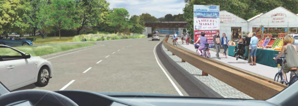
A DCR rendering shows improved passage for pedestrians and bicyclists along the Lambert’s property on Morrissey Blvd.
Neighbors, cyclists, pedestrians, and drivers weighed in energetically on the latest designs for the William T. Morrissey Boulevard revamp, with more than 50 comments submitted to state’s Department of Conservation and Recreation (DCR) after a June presentation of the 25 percent design.
The agency is grinding its way through a $3.2 million design phase for the frequently flooded thoroughfare connecting Kosciuszko Circle to Neponset Circle, though the former is not part of the planned redesign.
It envisions a DCR parkway bordered by biking and walking paths. Speed limits would be lowered to 35 miles per hour from 40, signals streamlined around some of the most chaotic portions of the roadway, and lanes dropped along the route in anticipation of a more logical traffic flow pattern.
Related: Time to make Morrissey more of a neighborhood roadway
Responses were mixed on the traffic alterations.
“Having lived and traveled on Neponset Avenue for over thirty years I have experienced many a traffic nightmare, but none I fear will compare as to what will happen if Morrissey Blvd. will be narrowed to two lanes each way,” wrote Deborah Moleca.
Some, like Dorchester resident Lynn Holmgren with the Livable Streets Alliance, wanted an even lower speed limit.
“At a minimum, the speed limit on Morrissey Blvd should be reduced from 40 to 30 mph,” she wrote. “The road must also be designed in a way that will help to self-enforce the speed limit and restrict large trucks. Removing concrete medians, narrowing travel lane widths, and rethinking curb offsets are several ways to achieve this.”
Others said the proposed reduction was sufficient or unnecessary.
“This is a boulevard,” one commenter noted.
The LivableStreets Alliance, Boston Cyclists Union Landline Coalition, Metropolitan Area Planning Council, WalkBoston, StreetsPAC Massachusetts, Dot Bike, and Mattapan Food and Fitness Coalition sent a joint letter to DCR offering general feedback on the route and making area-specific suggestions for some of the most fraught segments of roadway.
Among their highlighted suggestions: The “Ocean Parkway” section along Malibu Beach should be designed with a wide 8 to 10 foot sidewalk; keep only two through-lanes, rather than also allow for short sections with three lanes; and add a connection to the newly completed leg of DCR’s Neponset River Greenway, which has become an increasingly popular bike commute route.
“We understand that a connection between the two facilities will be designed separately, but the project extremity should still be looked as a gateway to a capital-intensive redesign,” they wrote. “Not only will this lead to a lack of legibility from the network perspective, but also create a major safety hazard for people walking or bicycling along Morrissey and going further.”
Most commenters were pleased that the redesign is taking place at all, with bicyclists in particular grateful for the prospect of a safe and traversable collection in lieu of braving the parallel and treacherous Dorchester Avenue.
“I would like to commend the DCR on their commitment to improving bicycling infrastructure along Morrissey Boulevard,” wrote Dorchester resident Jonathan Grenier. “Two of the real gems in Boston for cycling are the path along the harbor in Columbia Point to the north, and the bicycling paths from Port Norfolk out to Mattapan. As you mentioned in your presentation, the current paths are dangerous, disconnected, and unpleasant, and taking children along these paths should never be attempted. If the bicycling routes are connected safely and attractively, this would be an enormous quality of life improvement for residents of eastern Dorchester, Milton, and Mattapan.”
Proposed alterations near Neponset Circle stirred significant talk from commenters. The 25 percent design includes changes at Neponset Circle to allow two-way circulation under I-93, which Port Norfolk Civic Association president John Lyons wrote “is preposterous and a threat to public safety.”
Eliminating a southbound-to-northbound U-turn near a Dunkin’ Donuts at Freeport Street would also cause access issues, some posited.
Audrey Condon, who lives on Neponset Avenue, said she uses the Neponset Circle multiple times per day to enter and leave the neighborhood. Existing backups would be made worse if drivers had to continue through Neponset Circle to switch directions, she said. “Taking away the turnaround would create a massive hassle for us,” she wrote.
Other comments proposed the addition of traffic signals at various points along the stretch, including one near Conley Street.
The project timeline is dependent upon state funding, officials note. Each of the three Morrissey segments will likely take around two years to complete, starting with the vulnerable middle stretch from from Patten’s Cove Bridge to Freeport Street.
“The DCR will continue to engage with community organizations, elected officials, and various stakeholders who have diligently contributed to the furthering of this project,” a department spokesman said in an emailed statement, “and the agency looks forward to continued collaborative efforts to transform Morrissey Boulevard into an urban parkway that better connects the neighborhoods of Dorchester and South Boston with their waterfronts.”
DCR officials plan to host another public meeting in late summer or early fall to present a 75 percent design concept for the length of the parkway. All comments will be posted to the DCR site.
“Before this public meeting, the DCR will carefully evaluate feedback… specifically looking at suggestions to improve the multi-use facilities of this important thoroughfare to better serve drivers, cyclists, and pedestrians alike,” the department statement said.
Jennifer Smith can be reached at jennifer.smith@dotnews.com, or follow her on Twitter at @JennDotSmith


