May 20, 2010
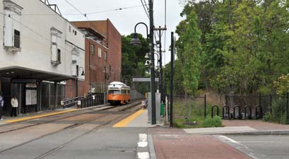
 Neponset Greenway: One of five proposed alternatives for extending the Neponset Greenway trail includes a route along the Milton side of the river. The path currently ends at Central Ave., shown above. Photo by Ed Forry
The state Department of Conservation and Recreation unveiled five proposals aimed at extending a path along the Neponset River from Milton’s Central Avenue to Mattapan Square this week. The proposed one-mile extension will connect Pope John Paul II Park, a 72-acre area between the expressway and the Neponset River marshes, to the Neponset Valley Parkway in the Hyde Park neighborhood. Currently, the 2.5-mile trail links Pope John Paul II Park to Central Ave.
Over 150 residents of both Mattapan and Milton crowded the dining room at the Foley Senior Residences in Mattapan Monday night to hear the proposals. A key issue remains: which side of the river should the trail run on.
Web Extra: View the DCR presentation shown at Monday's meeting.
The project, which could cost between $3 million and $5 million or more, is expected to lead to more signage along the trail, fencing for security, and a potential boardwalk and bridges, which would drive up the price. The project would be funded through the department’s capital budget or through federal funds, DCR officials said. They said $600,000 has been spent on planning and design.
The five proposals, put together by Crosby Schlessinger Smallridge LLC, include:
“Option A,” which runs exclusively along the Milton side of the Neponset River. It largely follows the high-speed trolley line and is separated from homes by the railway.
“Option B” starts out on the south side and then crosses over to the north side through a bridge. It is separated from homes through fencing and vegetation. It would exit through the Mattapan MBTA station and busway and onto the narrow River St. The option would also require some tree removal and disturbance of archeological sites at one time used by Native Americans.
“Option C” also would require tree removal and disturbance of archeological sites, as well as the construction of a boardwalk along a building. The trail stays on the northern side of the river. It would be separated from housing through River St.
“Option D” runs on the south side of the river but includes a connection to the north side in its middle.
“Option E” starts out on the south side of the river, crosses over to the north side, and then crosses back over to the south side. It follows the trolley line and is separated from homes through the railway.
Mary Burks of Mattapan said she preferred a combination of “Option D” and “Option E” because they would “serve both sides of the river.”
Rodney Bender, a Mattapan resident and self-described “tree-hugger,” said he wants to see both sides of the river connected. “I want to see it in my lifetime,” he added.
Asked which option they preferred, state Rep. Linda Dorcena Forry, who represents both Mattapan and part of Milton, and Mattapan District Councillor Charles Yancey also said they wanted a bridging of the two communities.
A request for comment from Gov. Deval Patrick, a Milton resident, was not immediately returned.
Some residents along the proposed routes raised concerns whether DCR would keep up maintenance, whether fencing between the path and river should be considered in order to prevent children from drowning and which law enforcement agencies would have jurisdiction. One Milton man spoke up at the meeting to say he was afraid that connecting the Milton and Mattapan sides would lead to an increase in crime.
But supporters of the greenway said DCR has a large capital budget, and the community could step in to help with maintenance. They also accused some of the concerns as “fear-mongering,” noting that Milton police, State Police and MBTA police could easily coordinate jurisdiction as they have in other areas.
Residents and others interested in the project are able to publicly comment to DCR on the proposals until June 25. A follow-up public meeting is expected afterwards, as well as a DCR-sponsored walk of the site in early June.
More information is available at the department’s website at www.mass.gov/dcr.
Villages:
Topics:
Tags:


