
August 16, 2017
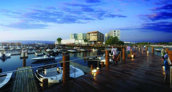
A rendering shows what a proposed re-development of the Port Norfolk waterfront might look like. RODE Architects image
Largely citing traffic and density concerns, Port Norfolk residents and neighbors reacted skeptically last week to the latest plans for a site on the peninsula along the Neponset River and Pine Neck Creek where City Point Capital is proposing a three-building wharf project that will include residential and recreational spaces.
The South Boston-based developer plans to raze the buildings on their 3.6-acres of land, the former MarineMax/Russo Marine site. Along with condominiums, developers are pitching a 25-room boutique hotel, 85 structured parking spaces, a 4,000-square-foot restaurant/café, and renovated boat storage and service facilities. The property also includes four acres of watersheet for marina use.
On Aug. 9, a well-attended meeting in the Port Norfolk Yacht Club that was hosted by the Boston Planning and Development Agency (BPDA) gave the general public its first look at a presentation of the Neponset Wharf project. The comment period for the current plan is open until Oct. 1.
City Point Capital principal Ryan Sillery, the project owner and developer, told those in attendance that the site is “a great place; we’ve put together a really great design.” With reference to boating out of the marina, he added, “It’s a real special place for me. I know it’s a long process and it can be hard to get your heads around it, but I can assure you there will be many more of these meetings and your input is very valid to us and we really want that.”
Kevin Deabler of RODE Architects said the primary concerns brought up throughout the public process so far have been traffic, scale, and usage. He also reviewed the executive summary of a Port Norfolk planning initiative in the 1980s.
The amount of density may not be the best fit for this site, said Paul Nutting, a Savin Hill resident with a long experience on waterfront issues in Dorchester. His remarks garnered applause from those at the meeting.
A GIS (geographic information system) analysis of assessing data showed that the residential area within the zone included 185 dwelling units, in mixes of condos, single-, and multi-family homes. Counting the hotel rooms, Nutting noted, the wharf project will essentially double the housing density on the port.
“I’m not averse to density as long as it’s at the right location,” he said, “and I don’t think the peninsula ,with a paucity of transit options, which is essentially car dependent, is the right location for density.”
Two mixed-use buildings would rise to eight stories in the plan, and one purely residential structure would have five stories.
Eric Robinson of RODE Architects walked the group through the development team’s thinking on the design. As zoned, the land could be used in its entirety as a marine storage or fish processing facility, he said, but they prioritized openly accessible green space while trying to maintain their intended density.
“Pulling the buildings and the massing together, and going up eight stories as we’re proposing,” Robinson said, “does allow us to manage the buildings on the site and create the open space that we think is a benefit to both the residents who will be living here as well as providing the access and things [to the community].”
Existing paved land area will be replaced with about two acres of new landscaped outdoor space, according to the presentation and filings with the planning agency.
Traffic was an immediate and enduring point of contention throughout the meeting. The site is reachable by three roads – Lawley Street, Walnut Street, and Port Norfolk Street, and the latter is one way as it passes through a residential neighborhood. This proposed project would have an entry point at Port Norfolk Street and an exit point at Lawley Street.
A basic traffic analysis, including on- and off-peak usage and seasonal changes, tracked current vehicle flow in and out of the neighborhood. Among the findings: Walnut Street gets higher volumes than Lawley Street, and traffic spikes dramatically on Saturday evenings, with events at Venezia bringing more than 100 cars driving in over an hour.
Many attendees were nonplussed by that assessment. An initial filing projected 1,440 new vehicle trips per day would pass through the area in connection with the new development.
“We do know, we who live in this port, what the traffic is, how many cars come in and out,” said long-time resident Ben Tankle. “We know all that, but we don’t know, because you people haven’t said a word about it, what is your project going to do to our traffic? We know what we have.”
Another attendee noted that the width of the roads on the port means that two cars on the same road make it impassable if one of them stops for any reason. “That’s only with the traffic that’s already in this neighborhood,” she said. “So what happens when all these properties do start coming in for those of us who have to work, or get our kids off the school in the morning? Does that mean I have to leave a half hour earlier to get my kids to three different schools? I don’t think that part has been examined.”
A further traffic study will identify opportunities for improving existing traffic as well as managing any new strain from the increased density.
The questions and comments continued:
To resident Maria Lyons, the matter of environmental integrity when the marina will be dredged was of concern, as was the potential of the project blocking waterfront views for residents.
Ralph Bruno, the longtime owner of Venezia Restaurant and the Boston Winery, said Sillery was an ideal developer for the site, although Brian Doherty, with the Boston Metropolitan District Building Trades Council, said the trades will side with the neighborhood if it opposes the project. He added that City Point Capital’s work in South Boston made him uneasy enough to suggest that for any promises that were made, the community should “get it in writing.”
Tim Czerwienski with the planning agency said he anticipates having “more than one” of the BPDA-hosted public meetings as the process goes on. “This is basically phase one of the review of this project,” Czerwienski said. “This is a multi-phase review.”
After the comment period ends at the end of September, the city will compile reaction from the public, from the project Impact Advisory Group, and from officials. They will then make a scoping determination summarizing all of the concerns and go back to the developers for a second draft of the project with planning mitigation for those issues.
Villages:

